

Benefits not remote
Benefits not remote
Benefits not remote
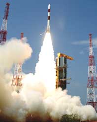
H igh quality three-dimensional terrain maps of India will now be available at affordable prices, as the Indian Space Resaerch Organisation (isro) successfully put in orbit a satellite specifically for cartographic purposes. Remote sensing satellite, Cartosat-1, was placed in a sun-synchronous orbit on May 5, 2005 from Satish Dhawan Space Centre, Sriharikota, Andhra Pradesh. Maps produced by Cartosat-1 will be especially useful for infrastructure development, town planning, local level planning in rural areas, land and water management and disaster and environmental impact assessments. isro spent Rs 250 crore to build the satellite and Rs 80 crore to launch it. Piggy riding was a microsatellie, Hamsat, launched specially for amateur radio operators.
Cartosat-I has two panchromatic cameras aboard for taking black and white photographs, with a resolution of 2.5 metres. Any object longer than 2.5 metres can be easily discernable in images taken with these cameras. "They will be finest-ever digital imageries available for civilian purposes,' said an isro spokesperson. isro says the satellite will start sending images to the ground in a month. It is technically capable of mapping each and every corner of the country in 128 days. Hyderabad-based National Remote Sensing Agency, an organisation under isro, will have the sole authority to sell the maps produced by Cartosat-1.


