

New quake fault lines can't hide beneath forests
New quake fault lines can't hide beneath forests
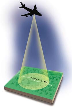
it might just be easier to predict earthquakes now. uk-based Leicester University researchers have successfully used a technology to detect fault lines, the causal location of earthquakes. The researchers used the light detection and ranging (lidar) method to detect fault line movements, which help predict earthquakes.
Earthquake prediction lidar helps in assessing the magnitude of the fault lines thereby throwing light on the recurrence of earthquakes. It is usually difficult to detect fault lines under thick forest cover but lidar penetrates deep forest cover making such zones visible.A lidar image of a landscape covered with a forest reveals the entire forest floor topography in high resolution (see box: New technology). This enables surface faults, fracture patterns, landslides and many other geological features to be resolved in unprecedented detail.


