

A Himalayan plunder
A Himalayan plunder
"LARGE parts of Uttarakhand now lie denuded ... the whole region is turning into a desert. If this trend continues for another 50 years, it will become impossible to save the Himalaya from total collapse," environmental activist Chandi Prasad Batt had said at a public rally in 1980.
One could trace the origin of such prophecies to the '70s with the emergence of the 'theory of Himalayan forest degradation The theory stated that after the year 1950, the Terai of the Himalaya had been witness to population explo people meant an increased demand for fuelwood, amilt of which was massive deforestation, the other ill effect soil erosion, loss of lands and frequent flooding followed by siltation of the plains.
However some dispute the manner in which the year 1950 is treated as a turning point in the history of Himalayann forest.Udo Schickhoff of the department of geography, Opemn- of Bonn, Germany, is one who believes that different Opepons of the Himalaya have undergone deforestation w ise-Ong lengths of time. Schickhoff s contention is that valley in Pakistan's upper Himalayan reaches has a ove. a period of nearly 200 years. He has undertaken POW"- research by pouring over historical data and con- muft field work and scientific mapping of the vegetation of the area.
Geoecological research, he convincingly points out, has mewrated more on the Nepal Himalaya and the Terai = of India and the results have been indiscriminately bol so the entire Himalayan region.
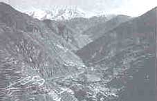
About the valley The Kaghan valley is in the western Himalayan region. It is located in Manshera district of North-West Frontier Province The border with Pakistan-occupied Kashmir lies it wwwds the east. The valley is about 100 km long and the upper watershed of the Kunhar river. The Kunhar a swo the Jhelum, south of Muzaffarabad. The climate of bpwa Kaghan valley remains humid all through the year. takv recieves an annual precipitation of 1,545 mm of cb 56 per cent is recorded between June and September.
The natural vegetation consists mostly of Pinus roxburghi forest higher altitudes, moist temperate forests are founJ. As& slopes in the sub-alpine belt, the natural vegetation a ono to Betula utilis forests, but on sunny slopes coniferous are followed by juniper woodlands. Above the tree-line aipene dwarf, scrub heaths and meadows thrive.
Slow but certain death Until the 19th century the western Himalaya were a thinly populated high mountainous region. Cedars from here were as ttmber in Mohenjo Daro. In 327 BC, Alexander the Great used these dense unspoilt mountains to conceal the Cultivated terraces reflect uncultivated values movements of his army.
Between the 12th and 16th centuries, the western Himalaya were considered untouched and inexhaustible. After that, the anarchy and uncertainity of the Durrani and Sikh rules restricted population growth and the extension of settlements and agriculture.
It was not until 1847 (the year British administration was introduced to the area) that the forest cover in this Himalayan valley began ficing the brunt of commercial exploitation. The relative peace and political stability in the valley provided the ideal conditions for the encouragement of trade and agricultural activities. The obvious outcome of increased prosperity was the increase in the local population.
Sunny slopes were reclaimed for agriculture by setting them on fire. Forests close to settlements began to degrade because of intensive grazing. Migratory flocks of birds and herds increased because agriculture expanded. The growing demand for timber in the lowlands increased the pressure on forests. In 1852, the deputy commisioner of Hazara district, J Abbott, vas ordered to arrange for the floating of Kaghan timber down the Kunhar river for the extension and supply of the Indus steam flotilla. The Syeds who formed the rural elite in Kaghan district raised objections because they were not prepared to share the compensation for the sale of timber with their labourers, the Gujjars.
The year 1855 was another milestone in the history of these mountain slopes as it was the year the Syeds were finally subdued. Hereafter, the area saw the launching of largescale logging operations. After the suppression of the Indian mutiny in 1857-58, the roads and railways were extended. Timber was needed to construct a railway line linking Lahore, Rawalpindi and Peshawar. The cedar forests were found to contain the best wood for railway sleepers. The government laid claim on every cedar tree in the Kaghan valley. The Himalayan forests began to be felled at a pace which surpassed the decimation carried out in every other period in history. Timber was also needed to deck up Murree, a hill station and for the military base at Abbottabad. All these demands were met by logging the virgin forests of the Kaghan valley.
Meanwhile, between 1860 and 1870 the area brought under cultivation increased by nearly 25 to 30 per cent. By 1870, the district gazetteer declared that "every area of cultivable land is under the plough." Indeed so vast was the area of land brought under cultivation during this period that the increase in arable land between then and now has been rather marginal.
Reincarnation?
With the largescale and ruthless exploitation of the forest cover in this area, matters went out of hand for the British government. To restore some sense of order, the British wanted control over burning, logging and forest grazing and easy access to timber. In 1857, all forest areas of Hazare district became the property of the government. But local villagers and permit holders were allowed to cut trees for their personal use and to apply for permission to plough new land for cultivation.
In 1864, the Indian Forest Service was established with Dietrich Brandis as the first inspecter general of forests. The Indian Forest Act 1865, led to the establishment of a separate forest department under the government of India. "It was the consequence of the uncontrolled exploitation of the forests upto that time" writes Schichoff.
The first conservator of forests in Punjab, J L Stewart, made strenuous efforts to preserve the cedar forests in the Himalaya from further exploitation. In 1872, the first permanent settlement of the district took place. After the permanent settlement, all public wastelands also came under the purview and supervision of the civil administration. According to the Hazara Forest Regulation No I I of 1873, the forest area within the Kaghan forest division was classified into government reserved forests (20,000 ha) and public wastelands (37,000 ha).
In 1879, these wastelands came to be caUed guzara forests. The forest department took over the management of the reserved forests. Extensivt silviculture management follow 10 and restrictions on forest use were imposed. But formulatiffg fore@ laws was one thing and enforcing them quite anoth The locals were reluctant and opposed to all such measurP Their traditional usufruct rights were now kept on hold. There were unending disputes over grazing rights. Harried for 0 officers now wrestled between making local people com with rules and quelling rebellion.
The classification of forests into restricted forests a guzara forests increased pressure on the guzara forests intensified forest degradation. Both the government as the villagers began nibbling at the guzaras. Deprived of the traditional rights, the villagers took no interest in sustainable development. The civil administrators were no experts at I est management either. Towards the turn of the century, use pressure increased tremendously because of population growth. Between 1868 and 1941, the population increased from 16,000 to 37,000.
Population was concentrated more in lower Kagh and it was here that the forests became sparser. For first time, severe landslides and problems of erosion were reported. About 100 years after their designation, forest cover of the guzara forests amounted arec to only 60 per cent of the original The reserved forests on the other hand bene fited from the forest conservancy measurd In these forests, the forest cover in 1966-67 and 1985 was about 89 per cent and 91 F4 cent respectively. "This is because of actions taken by the Indian Forest Service", poirc out Schickhoff. The valley's current cultural landscape took shape at the turn of the century. In the period 1901 to 1981, the population tripled from 3 7,000 to I 10,000.But settlements along forests began to quielty encroach upon forest land.
Cultivated terraces began to intrude into marginal areas and the guzara forever began to degrade futher. Gradual changes did take place. Forest margins because thinner and there was regression into scrul communities which were resistant to brova ing. Ground vegetation consisted of weeds arre this increased the soil erosion. Livestock increased fro% 60,000 heads to 200,000 excluding the large flocks belongj to the nomadic Gujjars. By 1940, even the reserved fore were being subjected to exploitation. During World War 11 3 demand for timber increased and natural regeneration could not keep pace with exploitation. "This was the second era of massive cutting of Indian forests," points out Schickhoff Today, just 16 per cent of the Kaghan valley can boast of a forest cover.
It has taken two centuries for the Kaghan valley to shed its trees. The population has increased by 40 per cent over the Iast 40 years. In the recent past, it has been observed that the natives seem to have reverted to cottage industry from agriculture and to part-time agriculture from subsistence farmi1y Inspite of this, it is proving difficult to drag the environment into taking a full circle, because what were once lush green slopes cannot be regreened easily despite serious attempts at afforestation.


