

Mega mishap
Mega mishap
devastating floods in Bangladesh claimed at least 800 human lives and seriously affected 35 million people in 39 out of the country's 64 districts last month, stumping experts and politicians: while the timing and magnitude caught the former completely off-guard, the government's initial determination to handle losses internally was washed away as it turned to international support for post-flood rehabilitation.
The water also overwhelmed capital city Dhaka, forcing itself through the embankments and floods walls constructed to protect its 12 million people after a similar catastrophe in 1988 (see box: As the water rose).
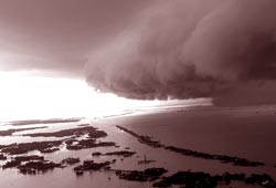
What caused it? The floods were caused mainly by the onrush of water from the upper catchments of the rivers Ganga, the Brahmaputra and the river Meghna (from India). Torrential rains played their part, too. Such inundation wasn't expected. Selim Bhuiyan, director of Bangladesh's Flood Forecasting and Warning Centre put it thus: normally, the Meghna floods between April to June, the Brahmaputra in July and August; floods from the Ganga occur in August and September. But this time all three basins roiled over simultaneously, in July. What exacerbated the situation, said Akram Hossain, director, Bangladesh Meteorological Department, was that a swollen Bay of Bengal obstructed water flow into the sea (see map: Boiling over; see box: Could it be?). According to Bhuiyan, this also increased the duration of flooding in central districts including Dhaka.
Government and opposition leaders failed to grasp the gravity of the situation, for the national road and highway network remained largely unaffected. In hindsight, it is clear that while these structures were flood-proofed after 1988 the rest of the flood plain, where the majority of people live, remained unprotected. According to experts, risen riverbeds through siltation and rampant construction on wetlands


