Danger mark
Danger mark

it's an annual pattern in Bangladesh. 10,117 hectares of land are washed away each year in devastating floods (Disaster Management Bureau report, 2003). The Jamuna erodes vast tracts along its course; the pattern of erosion along the banks of the Padma, Meghna and Teesta are equally destructive.
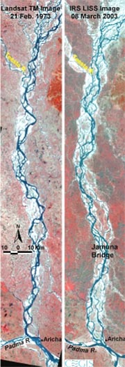
If such points of erosion, or how a river is poised to shift banks, could be gauged beforehand, specific measures could be taken that would protect thousands from losing their homes; immense damage to infrastructure would be checked. Precisely what geomorphologists at the Center for Geographic and Information Services (cegis) in Dhak are engaged in: they use satellite images to monitor bank-line changes based on annual river behaviour. These changes are also points of erosion, and a knowedge of such erosion reveals, in turn, the pattern of flooding. Satellite images help to monitor the extent of erosion; helping, over time, to develop tools to predict bank erosion.
Currently, cegis is busy is monitoring geo-morphological developments and bank erosion at different reaches of the western bank of the river Jamuna. Its experts have evolved a system of predicting erosion along the Jamuna, that flows from the northern Bangladesh border to the Ganga-Jamuna confluence. cegis hopes it is a dependable one.
The idea for the project, part of the Bangladesh Water Development Board (bwdb)'s Flood Action Plan, emerged from Garrit Klassen, a Dutch river expert. "Garrit saw the satellite images of Jamuna from 1973 to 1990 and came up with the idea. We started in 2000 and developed the method, using the British system of measurement to predict the erosion,' says Mominul Haq Sarkar, head of the cegis study team.
Would this help prevent floods? If the way the river shifts, so causing points of erosion, could be foretold, then embankments could be erected to protect the area. The predicted erosion for 2004 was presented for 16 locations along the western bank of the Jamuna.
To prepare a base map, cegis used 6-metre resolution irs panchromatic images (from institutions in the us and in India) of the Jamuna river taken between 2000 and 2003. Explaining the process, Sarkar told Down To Earth , "To predict where erosion could occur, one has to look for points along the outer bank of the riverbed, the bank of those dry stretches that flank both sides of the meandering water channel. The channel should be visible in dry season satellite images; its dry season width should be more than 200 metres. We compare images over some years to see changes. On that basis, we analyse how the river will behave, how it is likely to shift.'
"The Jamuna tends to erode along all its outflanks, along both straight stretches and at bends. Generally, the prediction tools are effective


